Bike Routes
I have had a few conversations recently with people about their own interest in biking to work or just using their bike to run errands. The conversation frequently gets down to how to get where they want to go safely and perhaps just as importantly feeling safe. Bike routes can be tricky to find. They are frequently not the same routes you would use a car to travel. In a city like Elgin, there is not a master map published, Google Maps bike routes are not always helpful, and generally the bike route infrastructure is incomplete. So it leaves bike riders needing other ways to figure out how they can get somewhere. I would like to share some of the lessons I feel I have learned in finding routes and set the framework for a series I will call "Bike Route Hacks."
Comfortable routes are in the perception of the rider based on their evaluation of the route conditions and their own skill and confidence. Some planners use frameworks to think about potential users such as categories of riders (children, most adults, enthused & confident, and strong and fearless) or the kind of routes (separated, protected bike path, quiet neighborhood streets, moderate volume street with space for bike riders, and high volume streets with little bike rider accommodation). The kind of space for bikes, speed of cars, and volume of car traffic are characteristics that have the biggest impact for my comfort levels.
Route exploration is very valuable and can make your rides and potential area of bike-ability all the greater. If you are trying to figure out a new route to a location, there are a couple ways to help reduce the stress and increase the joy.
P.S. So I am going to start profiling some routes in Elgin. I will try to describe and photograph different routes that provide illustrations of what to look for in route-finding in Elgin and also potential routes that others would find useful in getting around. I will call this series "Bike Route Hacks" for a couple of reasons. I think the term hack implies something important in this framework. Hacking is not really official or sanctioned. You will need to test my route hacks for yourself to insure they work for you as effective and safe routes. I generally stick to riding on streets or official bike trails, but some of my hacks have already included the occasional sidewalk, which requires special care when returning to streets. I look forward to sharing and hope they are useful. If you have a route hack you would like me to check out and profile, let me know.
Comfortable routes are in the perception of the rider based on their evaluation of the route conditions and their own skill and confidence. Some planners use frameworks to think about potential users such as categories of riders (children, most adults, enthused & confident, and strong and fearless) or the kind of routes (separated, protected bike path, quiet neighborhood streets, moderate volume street with space for bike riders, and high volume streets with little bike rider accommodation). The kind of space for bikes, speed of cars, and volume of car traffic are characteristics that have the biggest impact for my comfort levels.
- Space for bikes- There are a variety bike route accommodations. In a formal planning sense, here are the types of bike accommodations that are typical:
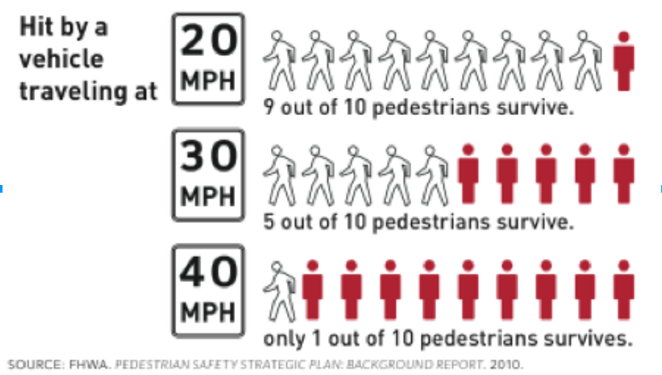
- Vehicle speed- Anytime traffic is going faster than 30-35 mph, my comfort levels are often being pushed, especially when there is not a lot of space designated for me and my bike. So looking for routes that have speed limits for cars that are capped at 35 mph and preferably 25 mph is one route characteristic to find. Posted speed limit is not the only factor in traffic speed. The wider a car's lane to occupy the faster a driver will probably go. Other traffic calming (car slowing) features are shorter distances between stops (i.e. stop signs or traffic signals), cars parked on street, frequent cross traffic or entering/exiting traffic, and even trees along the road. The perceived risk involved with speed is connected to the real risks involved with the physics of the situation.

- Volume of car traffic- So traffic volume would technically be measured in the number of cars a street serves in a given period of time, which can vary based on time of day and particular local uses. For a bike rider, who is not trying to do regional master planning for transportation, it is probably easier to talk about the types of streets, which are labeled based on their intended and realized traffic volumes. For our purposes the categories of arterial, minor arterial, collector street, and neighborhood street will do well to describe most of the situations bike riders in Elgin would find themselves in. The best metaphor to think about these streets would be to imagine a river basin or watershed. Way up the system are tiny little streams (neighborhood streets) that do not move a lot of water or terribly quickly. As you head down stream (from collector to arterial), volume increases. Eventually, this arrives at a raging river, which is the highway. These types can be easy to spot if the map looks like the graphic or it can be a perfectly square grid and based on the characteristics of the road itself, which is why Google Maps does not always have a helpful answer to "can I bike that route?".
 |
| Source: http://ntl.bts.gov/DOCS/images/GL/GL4007.GIF |
Route exploration is very valuable and can make your rides and potential area of bike-ability all the greater. If you are trying to figure out a new route to a location, there are a couple ways to help reduce the stress and increase the joy.
- First of all you can try and map it using an online or paper copy map. Try to get a sense for what those streets will feel like as a bike rider, instead of a car driver. Even if this doesn't give you a perfect route, it can be helpful to get a better sense of all the streets with which you might interact.
- Ask someone who is biking the area. Maybe even go for a ride together to check out the routes. A rider who is already using the route might be able to share all kinds of tips and tricks, from which signals pick up bike riders to how to avoid difficult hills to bike that a car driver never notices.
- Finally, ride it yourself. The less familiar with the route you are, the more time and patience for testing the route you should give yourself.
P.S. So I am going to start profiling some routes in Elgin. I will try to describe and photograph different routes that provide illustrations of what to look for in route-finding in Elgin and also potential routes that others would find useful in getting around. I will call this series "Bike Route Hacks" for a couple of reasons. I think the term hack implies something important in this framework. Hacking is not really official or sanctioned. You will need to test my route hacks for yourself to insure they work for you as effective and safe routes. I generally stick to riding on streets or official bike trails, but some of my hacks have already included the occasional sidewalk, which requires special care when returning to streets. I look forward to sharing and hope they are useful. If you have a route hack you would like me to check out and profile, let me know.


Comments
Post a Comment